2012 Perseid Meteor Shower Peaks This Weekend!!!

Perseid Meteor falling over the Pacific Ocean south of Hilo

The Perseids are here! As seen on National Geograhpic’s website. Every year we enter a swath of debris from Comet Swift-Tuttle sparking these “falling stars”.  Last year was a  bust with a full moon washing out all but the brightest ones.  As pictured below..
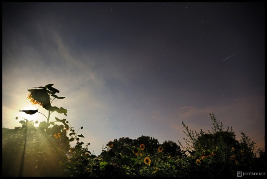
Perseid Meteor and Full Moon 2011

Perseid Meteor and Full Moon 2011

 Unlike last year, this year should be much better. The moon rises in the early morning as a crescent which is better than the bright full moon.  The best place watch is away from city lights where the light pollution takes over our night sky. Where ever you live just take a 30 minute drive out-of-town. This year we have a bonus!  Venus and Jupiter will align with the slender crescent moon in the eastern sky before sunrise in a dazzling morning sky show with a flurry of Perseid Meteors!  The best time to look is between 1am and 4am (NE) when the radiant is the highest in the sky. featured below…

Perseid Sky Map

 I have had the honor of photographing this meteor shower multiple times from many places. Last year I photographed it from Utah, Arizona and Pennsylvania and I’m planning on extending that streak to a couple additional states this weekend. Here are a few shots from past meteor showers.Perseid Meteor over the Utah Desert 2011.

Utah Desert 2011.Delta Aquarid - Glacier 2008

Delta Aquarid Meteor Shower 2008

Quadrantid Meteor Shower 2012

Quadrantid Meteor Shower 2012

Quadrantid Meteor Shower – Florida Keys

Perseid Meteor Shower

Perseid Meteor Shower 2010

Perseids – Big Island of Hawaii
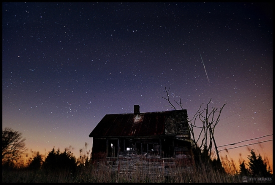
Leonids 2011

Leonids 2011

Leonid Meteor Shower – New Jersey 2011

Volcano and Perseid Meteor 2010

Volcano and Perseid Meteor 2010

The Kilauea Volcano Caldera, the Milkyway and a Perseid Meteor , Hawaii

Lyrids 2012

Lyrids 2012

Lyrid Meteor Shower 2012 – Virginia

Quadrantids in the Florida Keys 2012!

Quadrantids in the Florida Keys 2012!


 On a single night of the year you can see a falling star, but there are nights where the chances increase by a ton!  The Perseids start in late July and last until  about the 18th of August, the greatest activity of the shower will occur this weekend so be sure to go outside tonight and make a few wis

You can see these meteors in any direction in the sky. Make sure you bring a camping chair or blanket and look straight up without focusing on any single area in the sky. If you choose to photograph the shower make sure you use a lens which can cover a good portion of the sky and bring lots of snacks! Try not to look at cell phones or use flashlights that aren’t “red lights” this damages your night vision. When you first arrive at your sight make sure you allow 10-15minutes for your eyes to adjust to the night sky. Do not look at or into any light sources, it will tak you another 15 minutes for your eyes to adjust into (night mode).

Check back for a follow up to the shower and happy meteor hunting!

Combining Seasons – An October Nor’Easter 2011

Here are a couple of pictures I took while out Saturday during the 100 year storm.  I have always wanted to combine the seasons of Fall and Winter into one photograph, but conditions never worked out no matter where I was during the fall.  It could not have been any better than this past weekend.  The fall foliage was at it’s peak when this storm hit. Six inches of heavy wet  snow gave tremendous contrast to the vibrant colors in Autumn.

Chester Creek, Pennsylvania.

The yellow leaves on this tree stand out from the monochromatic landscape.

 The combination of the heavy wet snow on trees that are still bearing leaves made for dangerous and deadly conditions. This tree had just split across the road as we pulled up.  While standing out there I heard four seperate trees cracking and falling to the ground.  Needless to say, we couldn’t enter the state park because the road was littered in trees. A park ranger and I continued north under the tree to the enterance of the park. If I was going to continue it was going to have to be on foot.

I have driven 100 miles in a full blown Nor’Eatser, i’ve camped in 60mph wind gusts and 30″ of snowfall. I was more scared of this storm than any other winter storm I have documented over the last 10 years.

Sadly, at least 18 people have lost their lives in this historic storm.  Many of  them could have been avoided and some of them were just bad luck. You should now prep yourself on what you need to do to stay safe this winter. It could be a long one, and it’s still 6 weeks away from the starting line.


Halloween Weekend Snowstorm Headed for the Northeast?

OCTOBER NOREASTER UPDATE: 10.29.2011 – 11:59pm


We have received 6-10″ of snow from this powerful October Nor’easter. It has pulled out of the region leaving us with many downed trees and powerlines. 


SNOWSTORM UPDATE:   10.28.201  –  4:30pm


WINTER STORM WARNING IN EFFECT FROM 8 AM SATURDAY TO 2 AM EDT SUNDAY
UNTIL 6:00AM EDT

Urgent – Winter Weather Message
National Weather Service Mount Holly NJ
352 PM EDT Fri Oct 28 2011

Hunterdon-Somerset-Chester-Montgomery-Bucks-
Including The Cities Of, Flemington, Somerville,
West Chester, Norristown, Doylestown

, Winter Storm Warning In Effect From 8 AM Saturday To 2 AM Edt
Sunday,

The National Weather Service In Mount Holly Has Issued A Winter
Storm Warning For Heavy Wet Snow, Which Is In Effect From 8 Am
Saturday To 2 AM EDT Sunday.

* Accumulations, 3 To 6 Inches. The Highest Amounts Mainly Across
The Higher Elevations And On Non-Paved Surfaces. Snow could exceed these totals depending on the track.

* Timing, Rain Will Develop After Midnight Tonight, Then Mix With
And Change To Wet Snow During Saturday Morning.

* Impacts, Hazardous Travel Developing, And The Heavy Wet Snow
Will Likely Weigh Down Trees Which Still Have Leaves On Them.
This Will Lead To Some Downed Trees And Power Outages. The Wet
Snow May Fall Heavy At Times During The Height Of The Storm,
Locally Increasing The Accumulation Rate.

* Winds, North 15 To 25 Mph With Gusts Up To 30 Mph.

* Temperatures, In The Upper 30s To Lower 40s, But Then Dropping
To Near Freezing Saturday Night.

* Visibilities, Reduced To Well Under A Mile At Times.

Precautionary/Preparedness Actions,

A Winter Storm Warning Means Significant Amounts Of Snow Are
Expected. Strong Winds Are Also Possible. This Will Make Travel
Very Hazardous.

Snowfall totals now predicted to be around 3-8″for central Chester County, Pa and 6-10″ for northern Chester County,PA. Keep an eye on the weather.:00:00 AM


SNOWSTORM UPDATE : 10.28.2011 –

The possibility of a snowstorm impacting the Philadelphia region with more than 6″ of snow is more likely now than it has been. As of now Philadlephia could see between 3 6″, West Chester 4-8″ , French Creek 6-10″ and then North and east into the Poconos could see over a 12″ of snow when all said and done….

Time to clean out my car and charge my batteries.. It could be a long weekend.

Documenting the strong winds and beach erosion associated with the Christmas Storm of 2010. Barnegat Light, NJ

Are you ready for another long winter in the mid-atlantic and northeast ?  This photo is from February 2010 when we received two Nor’easters in four days, each dumping 3 feet of snow.

Snowmageddon 2010

 The potential snowstorm could start by early Saturday morning and last through the day, that is if it even develops. Either way, I will be keeping a close eye on the weather to see what my chances are at chasing the  fall colors covered in our first snow. The possiblity of up to 3″ is forecasted for my area, but if I travel to the north (25-60miles) I could potentially see snow totals near 8″+ , but with less foliage on the trees. I’m going to stay further south and hope for a fresh snow on the colors of autumn during peak conditions right in my area.. You do not  need to travel far to find great photo ops sometimes.

Snowmageddon 2010

Space Shuttle Discovery’s Last Transit Over the United States

Photo of the Day: 3.10.2011

Discovery’s Final Transit  

3.8.2011  –  7:23:24pm to 7:25:49pm EDT.  Chester County, PA

It’s was upsetting to know that Tuesday night would be the last time to see the Space Shuttle Discovery in the night skies over my town. I was 4 years old when Discovery first launched in 1984 and it’s sad to see something I’ve known for so many years retire. I have only seen it once in person when I was very young, but yet there was something about that visit to the Kennedy Space Center that inspired me. I can still picture clearly the Discovery being slowly rolled out to the launch site as a kid in the 80’s and I feel very fortunate to be able to photograph its final transit last night. The clouds parted briefly allowing me the two minutes I needed for this shot. I think the clouds added some interesting colors to the image and the crescent moon was a special bonus on a special night. The space shuttle Discovery and the ISS sweeping by the Pleiades with the hanging crescent moon and moon corona setting in the west. You can’t beat that for a farewell to almost three decades of service and 39 missions under the belt. Hope you enjoy this image as much as I enjoy creating it.

 Thanks Discovery! You will be missed!

Lake Effect Snow Machine Cranks Up!!

The Lake Effect Snow Machine is cranking out feet of snow in many locations, some locations will get over 3 feet of snow. Some areas have recorded it snowing for more than 75 hours. With a new, “more powerful” storm on the horizon for this upcoming weekend there is no tell when the snow may end. Not only the possibility for a major snow event for the East Coast, the coldest air of the season will plummet behind the biggest storm of the year! Enhancing even more lake effect snow on top of the initial storm! This winter is looking like it could be a repeat of last year, and if so, I am looking forward to it!  Here are some photos taken yesterday December 6th, 2010 from Edinboro, PA just south of Erie.

This slideshow requires JavaScript.

Photos by Matt Simons. (Chewy Simons). Thanks Matt!  Hope you camera survived the intense snow and wind!

The Eagle Has Landed

This morning was dark and dreary, just the way the Bald Eagles like it around here. Usually, every morning it rains they are out cleaning themselves and picking fish out of the stream.  This morning was very nice as the Eagles sat in front of a changing forest in autumn. Here is one shot from this morning of the female taking flight after a fish. How do I know it’s a female? Females are almost always larger than the male. Yup I said it!

Super Storms Drop Hail and Deadly Lightning!

Monday night, October 11th 2010: Severe Weather pushes across PA along a front coming out of the Great Lakes. This storm was born in Lancaster County, Pa and moved East towards Philly.  Amazing Structure throughout the storm! Kind of resembles my “Midnight Lightning” photo that is currently in a National Geographic Photo Contest with Energizer Batteries.

Remnants of Tropical Storm Nicole Brings Historic Flooding to Northeast and Mid Atlantic

September 30th, 2010. Tropical Storm Nicole is pumping massive amounts of moisture up the eastern seaboard bringing heavy rains, tornadoes and damaging winds to many locations. Flood Warnings were in places for over 48 hours as heavy rain continued to fall over the same areas.  During the afternoon several storms showed weak to moderate mid/low level rotation due to a strong vertical shear profile. The result, a Tornado Watch was issued by the National Weather Service until 8pm EST. As these storms ripped though my area, I was able to capture a mid level funnel on video. Here are some photos from the historic flooding, which occurred September 30th and October 1st, 2010

Hiding from the Rain.

This is where the British crossed the Brandywine to defeat us at the Battle of the Brandywine.  Oddly enough it was fought on September 11th, 1777. This was a key victory for the British, it left Philadelphia undefended and the British took control of the capitol on September 26th, 1777, and held control until June 1778.   This photo was taken October 1st, 2010.

Residential evacuations take place when the flood stage reaches around 12feet. The river was forecasted to rise up to 14feet, but It went higher than that.  Many people had significant water damage along the Brandywine.

Only a portion of a fence peaks above the water. Many Locations were completely submerged with up to 18feet of water!

Heavy Rain and strong winds  continued to blast us most of the Day Thursday.

Downtown West Chester, Pa

As night fell upon me, the rain began to intensify ten fold. Rainfall rates of 2″+per hour soaked us all night.

10:30pm. West Chester, Pa

Walking home in the rain

After a very long night, many people wake up to see the damage caused by the historic rainfall. We really haven’t seen any rain in almost 1 month before this system decided to march on in. When all said and done nearly 10″ of rain fell in less than 24hours. This was the result.

Colors of Autumn are Coming!


As August fades, and September’s cooler temperatures settle in, the leaves begin the final stages of their lives. We are all often in awe when the leaves change from a  lush green to a vibrant yellow, orange or red. It often raises questions such as, “Why do leaves change color in autumn?  Why do some trees turn yellow, orange and others red? How come the color varies in intensity from year to year?” Well what if I said the leaves are always yellow and orange and the green just covers it all up? It is true, these colors exist in the leaves all year and are covered up by the green chlorophyll.


The Fall Leaf Cycle starts at the end of summer with the shortening of the days and cooler nights. At that point, the trees do not receive enough light to produce food for themselves, and the production of chlorophyll is haulted.  Some trees that turn fire engine red, like a Maple ,

have glucose trapped inside it. A combination of sunlight, shade, and the cold nights help turn the glucose into this red color we see.  I have seen some of the most spectacular colors of my life in New England and along the Appalachian Trail. Shenandoah National Park offers some of the best vistas and hiking trails in the East! 

This picture was published in Popular Photography and Imaging Magazine October 2008. Itwas taken in Shenandoah National Park during a weekend camping expedition.


During the Winter, the tree will loose  it’s leaves so it can survive the harsh season ahead. My Autumn usually begins around the second week of September. The weather patterns seem to change and cooler air is filtered down like clockwork making beautiful fog-filled scenes at sunrise and sunset. Like this..

or this…

or this…

Even this morning, I was blessed with some nice low-lying fog and a beautiful  morning sun halo.

You are not just limited to photographing leaves and trees, you can also photograph activities that take place during this season, or incorporate them into your shot.

Riding Harley Davidson’s in New England.

 or fishing in Vermont..

Maybe all you need is a little good luck this fall!

I love taking hikes through Ricketts Glenn State Park in Pennsylvania! You can see so many beautiful waterfalls and thick forests filled with photo ops!

Check out the Green Mountains of Vermont!

Cleaning up after a MegaStorm


Residents of East Goshen Township  are still picking up after an intense Supercell Thunderstorm rocked  the area on June 24th, 2010.  Three weeks later destruction can be seen everywhere. Winds were recorded between 90 and 100mph. A Tornado warning was issued but not confirmed. Here are some photos I took after the event.

This slideshow requires JavaScript.

http://www.dailylocal.com/articles/2010/06/26/news/doc4c25fb400a710290335261.txt