Photo of the Day: 2.9.2011 – Stormy Sunrise – St.Thomas, USVI. August 2006


Photo of the Day: 2.9.2011 – Stormy Sunrise –  St.Thomas, 2006

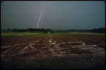
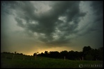
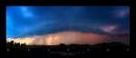
I woke up around 4am and was extremely pleased to see thunderstorm activity over the ocean. I anticipated a super sunrise so I left the resort and headed to the beautiful beaches on St. Thomas’ southeastern coast. I started off with lightning shots before dawn started to make its presence known, but It wasn’t until the storm passed less than two miles south of my position that things started getting interesting. The isolated thunderstorm became illuminated by the light of dawn, and was accompanied by lightning once again pouring out of the now glowing yellow, red, orange, purple and pink storm. The only problem was the pain and agony I was experiencing while taking these photos. I was being attacked by what is locally called No-Se-Um or Vampire Bugs. The bite of a sand flea really feels like the sting of a bee. It will leave big red dots and whitish welts wherever you have been hit. I had hundreds of welts on my legs, so please enjoy this picture!

Super Storms Drop Hail and Deadly Lightning!

Monday night, October 11th 2010: Severe Weather pushes across PA along a front coming out of the Great Lakes. This storm was born in Lancaster County, Pa and moved East towards Philly.  Amazing Structure throughout the storm! Kind of resembles my “Midnight Lightning” photo that is currently in a National Geographic Photo Contest with Energizer Batteries.

Cleaning up after a MegaStorm


Residents of East Goshen Township  are still picking up after an intense Supercell Thunderstorm rocked  the area on June 24th, 2010.  Three weeks later destruction can be seen everywhere. Winds were recorded between 90 and 100mph. A Tornado warning was issued but not confirmed. Here are some photos I took after the event.

This slideshow requires JavaScript.

http://www.dailylocal.com/articles/2010/06/26/news/doc4c25fb400a710290335261.txt

SEVERE STORMS BLAST CHESTER COUNTY

Friday May 14th, 2010.

After Work, I went to work. Chasing Severe Thunderstorms racing across Lancaster County, PA. Deadly cloud to ground lightning, fierce winds and small hail pounded my car as I made my way through southwestern Chester County to intercept the storm. As the initial storm passed I noticed more thunderstorm development occurring to my west through rumbles of thunder accompanied by bolts of lightning. The storms were back-building which meant four more hours of lightning for me. Here are a few pictures from the chase!

More Storm Chasing Photos at www.jeffberkesphotography.com

SEVERE WEATHER ALERT!

Thank the Bermuda High off the coast of Southeastern US for our recent warm weather, It’s seems as if we jumped spring and went right into summer.  The temperature reached 90 degrees here to and with a strong cold front moving our way you can expect severe weather to break out across the eastern seaboard.  Storms are beginning to explode over the Mississippi Valley and will be moving through our area tomorrow afternoon and evening. You can expect winds in excess of 60mph, hail, frequent lightning and a possible twister isn’t completely out of the question.

This is what you can expect to see tomorrow.