We were placed in a moderate risk area for severe weather on Thursday July 27th, 2012. Everything was in place to get dangerous yet magnificent storms. I haven’t had a lot of time to chase lately, basically none. Which is very rare, I have missed 7 chases in a row, but not this day! As storms fired up over lake Erie in NW Pennsylvania , I collected all of my gear for the day and played a waiting game. I really wanted to photographed the storms in the evening around sunset so I picked southeastern, PA where is it flat and wide open in most areas. I get tired of chasing in the sticks, it’s too dangerous with falling trees and branches. Even though that doesn’t stop me, I choose to bypass that idea and go for the fields.

Setting up for the Shot
It is one thing to “chase”, but it’s another to capture your subjects in the most dramatic way. Composition, lighting, depth of field and exposure are all very important in creating stunning photos. If you don’t get it right the first time, you don’t have a second chance. I spent about one hour looking for a good spot to set up. I found many photogenic locations but parking was an issue, with cars and Amish Buggies all around, it became a challenge in itself. I finally found my spot as the storms approached from the Northwest.

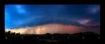
It’s coming!
I had a few cameras rolling the entire time. Two running HD video and my “Beast” the Nikon D3, taking the stills.

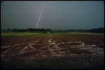
Corn Storm
The clouds were so dramatic this particular evening in SE PA. The right time of day, cloud thickness and the intensity of the storm all contributed to its beauty. Winds started to pick up and gusted to near 60mph. Some trees were completely snapped at the base, and I am talking 50 foot trees with a diameter of 2 feet! Dirt began to rise up from beneath to corn as lightning began to dance about the horizon 3miles to my northwest. I knew there was a reason why I had to pass up chases earlier this year. It was because this storm had more to offer than most storms.

Sudden Death
I always feel like it’s me (Jeff Berkes) vs. Mother Nature when confronting a storm, summer or winter. I love to get right in front of them and feel the power it has to offer. For me it is just about experiencing an event. The photos come 2nd as a way to share my experience with others, but in reality, if I do not get good shots, I do get frustrated! I spent about 10 hours that day chasing and photographing instense lighting until the wee hours of the morning. I took over 1000 photos and shot around 5 hours worth of video. IHope to get to it soon so check back for more storms chasing photos from 2012.

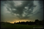
Looking East
This was looking east towards Philadlephia as the Shelf Cloud came overhead.

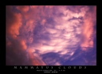
Barreling Through
This photo is from looking down the other end of the road. Shelf Cloud / Wall Cloud passed overhead, I looked behind me and saw yet again some of the most dramatic and beautiful cloud formations. There was weak rotation, but lots of movement in the clouds, it was simply stunning. Another Severe Thunderstorm Watch has just been issued for our area until 10pm tonight. These storms will not form the incccredible line like we had on Thursday, but we could see some very intense winds and lightning. Have a safe weekend! More photo and videos to come!
Sunday on Good Morning America they are going to feature some photos I took from this Chase, be sure to check it out!