
Check out these photos from last Thursday’s Chase!! Storms lined up one after another (Training) I basically didn’t have to do much except to wait for each storm to pass until I saw the right one.
Monthly Archives: May 2010


SEVERE STORMS BLAST CHESTER COUNTY
Friday May 14th, 2010.
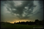
After Work, I went to work. Chasing Severe Thunderstorms racing across Lancaster County, PA. Deadly cloud to ground lightning, fierce winds and small hail pounded my car as I made my way through southwestern Chester County to intercept the storm. As the initial storm passed I noticed more thunderstorm development occurring to my west through rumbles of thunder accompanied by bolts of lightning. The storms were back-building which meant four more hours of lightning for me. Here are a few pictures from the chase!


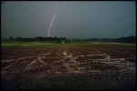

More Storm Chasing Photos at www.jeffberkesphotography.com
Severe Weather NEWS!
What spells disaster?
A heat wave with a approaching cold front is the correct answer. The mercury has already hit 94 degrees and it’s only 1:30pm in the afternoon. Tomorrow afternoon a strong cold front sweeping across the plains will make it’s way towards the east coast. A “Bermuda High” positioned off the SE coast will drag hot and unsettled weather from the Gulf of Mexico and spread it north along the Appalachians. When the approaching cold front hits this mass of warm moist air, Severe thunderstorms will explode bringing tornadoes, hail, deadly lightning and strong winds. Be prepared for the possibility of severe weather Sunday afternoon into Sunday night. This looks like it could be our first major thunderstorm activity of the year.
Tornado activity has been increasing over the last two weeks across the US after a record low start.

Funnel Cloud about to touch down.
