2012 Perseid Meteor Shower Peaks This Weekend!!!

Perseid Meteor falling over the Pacific Ocean south of Hilo

The Perseids are here! As seen on National Geograhpic’s website. Every year we enter a swath of debris from Comet Swift-Tuttle sparking these “falling stars”.  Last year was a  bust with a full moon washing out all but the brightest ones.  As pictured below..
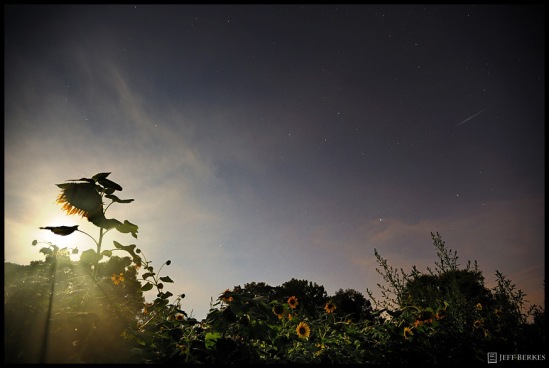
Perseid Meteor and Full Moon 2011

Perseid Meteor and Full Moon 2011

 Unlike last year, this year should be much better. The moon rises in the early morning as a crescent which is better than the bright full moon.  The best place watch is away from city lights where the light pollution takes over our night sky. Where ever you live just take a 30 minute drive out-of-town. This year we have a bonus!  Venus and Jupiter will align with the slender crescent moon in the eastern sky before sunrise in a dazzling morning sky show with a flurry of Perseid Meteors!  The best time to look is between 1am and 4am (NE) when the radiant is the highest in the sky. featured below…

Perseid Sky Map

 I have had the honor of photographing this meteor shower multiple times from many places. Last year I photographed it from Utah, Arizona and Pennsylvania and I’m planning on extending that streak to a couple additional states this weekend. Here are a few shots from past meteor showers.Perseid Meteor over the Utah Desert 2011.

Utah Desert 2011.Delta Aquarid - Glacier 2008

Delta Aquarid Meteor Shower 2008

Quadrantid Meteor Shower 2012

Quadrantid Meteor Shower 2012

Quadrantid Meteor Shower – Florida Keys

Perseid Meteor Shower

Perseid Meteor Shower 2010

Perseids – Big Island of Hawaii
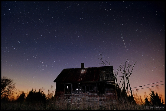
Leonids 2011

Leonids 2011

Leonid Meteor Shower – New Jersey 2011

Volcano and Perseid Meteor 2010

Volcano and Perseid Meteor 2010

The Kilauea Volcano Caldera, the Milkyway and a Perseid Meteor , Hawaii

Lyrids 2012

Lyrids 2012

Lyrid Meteor Shower 2012 – Virginia

Quadrantids in the Florida Keys 2012!

Quadrantids in the Florida Keys 2012!


 On a single night of the year you can see a falling star, but there are nights where the chances increase by a ton!  The Perseids start in late July and last until  about the 18th of August, the greatest activity of the shower will occur this weekend so be sure to go outside tonight and make a few wis

You can see these meteors in any direction in the sky. Make sure you bring a camping chair or blanket and look straight up without focusing on any single area in the sky. If you choose to photograph the shower make sure you use a lens which can cover a good portion of the sky and bring lots of snacks! Try not to look at cell phones or use flashlights that aren’t “red lights” this damages your night vision. When you first arrive at your sight make sure you allow 10-15minutes for your eyes to adjust to the night sky. Do not look at or into any light sources, it will tak you another 15 minutes for your eyes to adjust into (night mode).

Check back for a follow up to the shower and happy meteor hunting!

Big Storms Make Big Impressions – July 2012 Pennsylvania GMA

We were placed in a moderate risk area for severe weather on Thursday July 27th, 2012. Everything was in place to get dangerous yet magnificent storms. I haven’t had a lot of time to chase lately, basically none. Which is very rare, I have missed 7 chases in a row, but not this day! As storms fired up over lake Erie in NW  Pennsylvania , I collected all of my gear for the day and played a waiting game. I really wanted to photographed the storms in the evening around sunset so I picked southeastern, PA where is it flat and wide open in most areas. I get tired of chasing in the sticks, it’s too dangerous with falling trees and branches. Even though that doesn’t stop me, I choose to bypass that idea and go for the fields.

Setting up for the Shot

It is one thing to “chase”, but it’s another to capture your subjects in the most dramatic way. Composition, lighting, depth of field and exposure are all very important in creating stunning photos. If you don’t get it right the first time, you don’t have a second chance. I spent about one hour looking for a good spot to set up. I found many photogenic locations but parking was an issue, with cars and Amish Buggies all around, it became a challenge in itself. I finally found my spot as the storms approached from the Northwest.

It’s coming!

I had a few cameras rolling the entire time. Two running HD video and my “Beast” the Nikon D3, taking the stills.

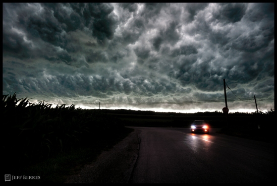
Corn Storm

Corn Storm

The clouds were so dramatic this particular evening in SE PA. The right time of day, cloud thickness and the intensity of the storm all contributed to its beauty. Winds started to pick up and gusted to near 60mph. Some trees were completely snapped at the base, and I am talking 50 foot trees with a diameter of 2 feet! Dirt began to rise up from beneath to corn  as lightning began to dance about the horizon 3miles to my northwest. I knew there was a reason why I had to pass up chases earlier this year. It was because this storm had more to offer than most storms.

Sudden Death

Sudden Death

 I always feel like it’s me (Jeff Berkes) vs. Mother Nature when confronting  a storm, summer or winter.  I love to get right in front of them and feel the power it has to offer.  For me it is  just about experiencing an event. The photos come 2nd as a way to share my experience with others, but in reality, if I do not get good shots, I do get frustrated! I spent about 10 hours that day chasing and photographing instense lighting until the wee hours of the morning. I took over 1000 photos and shot around 5 hours worth of video. IHope to get to it soon so check back for more storms chasing photos from 2012.

Looking East

Looking East

This was looking east towards Philadlephia as the Shelf Cloud came overhead.

Barreling Through

Barreling Through

This photo is from looking down the other end of the road. Shelf Cloud / Wall Cloud passed overhead, I looked behind me and saw yet again some of the most dramatic and beautiful cloud formations. There was weak rotation, but lots of movement in the clouds, it was simply stunning. Another Severe Thunderstorm Watch has just been issued for our area until 10pm tonight. These storms will not form the incccredible line like we had on Thursday, but we could see some very intense winds and lightning. Have a safe weekend! More photo and videos to come!

Sunday on Good Morning America they are going to feature some photos I took from this Chase, be sure to check it out!

Double Eclipse! (a preview)

WOW!!  I haven’t made a post  since April.  I am long overdue, but it has been for good reason.  I have had 15 workshops since April, one of them being to Arizona where we photographed many iconic locations including the Great “Ring of Fire” Annular Solar Eclipse over Horseshoe Bend in northern Arizona. I have also photographed the partial eclipse of the “strawberry” moon in early June, follow by the “transit of Venus” crossing the surface of the Sun, the following night. Three eclipses in just as many weeks, So lucky to have been apart of them all. The eclipse BlogEntry is coming next week! This is just a  little teaser of what is to come! Enjoy! We all arrived at 12 noon (5 1/2 hours before the eclipse began, just to “claim” our spot) and I’m glad we did.

Annular Eclipse May 20th, 2012 – Northern Arizona

Annular Eclipse – Horseshoe Bend, Arizona, May 20th, 2012

(above)The eclipse started at 5:32pm and ended beyond sunset around 7:24pm. This image was taken in the final minutes before the sun set in it’s partial eclipse phase.  

(above) This photo was created during the Maximum Eclipse Phase around 6:34pm on Sunday May 20th, 2012.

   Be sure to check back next week for the full post! Cheers! Jeff

2012 Lyrid Meteor Shower: A Look Back

Meadow In The Sky

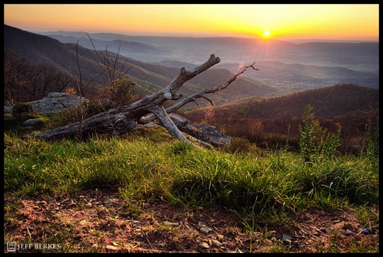
I found myself at 3,500ft in elevation with crystal clear skies on Friday April 20th, 2012. Being “Park Week”, I had no choice but to visit a long time friend of mine; Shenandoah National Park in Virginia. With the forecast looking poor during the peak activity, I arrived a couple of days early to  maximize my chances at a clear night. The first night was clear, but the dew point was causing issues with creating tons of condensation, which formed on everything. Things got a little hairy at point when a black bear approached us at 11pm in the pitch dark. I didn’t realize he was there until I heard a stick break and then noticed the bear 50 feet away. He growled and made noises, but kept on moving towards the east with no issues at all.

Sunset was even a pleasant palette of pastel colors in the western skies facing West Virginia

Valley View

Shenandoah Celebrated it’s 75 year anniversary last year as I celebrated my 12th year there at the highest Point in the Park, Hawksbill Mountain

Self Portrait - Hawksbill Mountain

Rain water created tiny pools of water along the highest cliffs in the park

Cliff Water

The second night there wasn’t a problem with condensation forming on my gear because we had gusty winds near 40mph or higher along the ridge preventing that from happening. The sturdy tripod made all the difference this night taking the stronger winds. Keeping the tripod low to the ground increases the stability. A steady rain, followed by 6″ of snow blocked any chance of observations for the “peak night”.  But the night before offered some gorgeous views of the heavens.

2012 Lyrid Meteor


The TOP photo is featured on MSN Photo Blog.. Check it out here.  http://photoblog.msnbc.msn.com/_news/2012/04/27/11434037-looking-back-at-the-lyrids

2012 is a great year for meteor showers unlike 2011. The next “major shower” is May 4/5, but the full moon block out all but the brightest meteors.


2012 Lyrid Meteor Shower Peaks This Weekend!

A Lyrid meteor over the Presidential Range, NH

A Lyrid meteor over the Presidential Range, NH

The Lyrids are almost here! It’s been a long 3 months since there has been a meteor shower to write home about. This weekend the condition will be perfect! As long as you have clear skies, viewing these meteors won’t be hard at all. The shower will peak Saturday night April 21st into the morning hours of April 22nd. If you can pull an “all night ‘r”  I suggest you do it that night.. If the forecast isn’t looking good for your area,  try to view the shower the night before, there will still be meteors as the shower starts on the 16th and ending on the 24th of april.

Sky Chart

Sky Chart

I have seen and heard reports of some fireballs in the evening as the radiant breeches the horizon. Look for the bright fireballs between 8pm and 10pm.

Perseid Fireball over Kauai

Expect 15-20 meteors per hour. In years past, there have been records of the shower going crazy peaking  over 100 meteors per hour. We don’t know what it will be like this year until it’s over.  This year, I will be perched up into the mountains high above light pollution. I’m hoping for clear skies!

 Virginia Skies

Let me know if you see any!

Keeping Your Head Up

Random Meteor - March 2012

Random Meteor - March 2012

I drove 3 hours, about (180 miles) to view the launch attempt at Wallops Flight facility in Virginia, Thursday night, March 22/23, 2012. Weather has been insane across much of the country, but this night seemed worth the trip. With clearing in the forecast, I left Pennsylvania around 8:45pm and arrived on Assateague Island National Seashore around midnight. The weather was perfect for the first 45 minute’s, then some clouds started to pass through. I really wanted this to happen after driving a good distance, but as the skies cleared another issue came up and the launch was cancelled. I would be lying if I said it didn’t bother me, but I made the best out of the trip. I continued to shoot through the night working on some personal projects. I started to see a few meteors  fall from the same location in the sky.  I ended up catching this falling star between the clouds in the early hours of Friday morning. Seeing a few meteors really made the trip worth it, and catching one on “film” made it even better. New meteor shower discovered?  The point is you can predict all you want, but there will always be unseen issues and surprises along the way, and you won’t know what they will be until you put yourself out there. I plan to capture the mega launch of 5 rockets in 5 minutes again this week.  The skies will be clear as weather patterns are shifting, bringing in a new wind. Lets hope that the ” planets will align” this week and give us what everyone has been waiting for!

LAUNCH OF THE NEW WEBSITE!

Jeff Berkes Photography just got a drastic overhaul on the website! New and improved galleries make viewing all  galleries faster and more enjoyable!

Whats new with the website?

Well, just about everything! The entire format has changed, litterally. The “image collection” has a brand new format with large thumbnails. Click on any thumbnail to enlarge it, see captions and descriptions for each image, click on that image again to return to the thumbnail gallery, simple right?

 The “Photo Tours” page has up to date information on 2012 workshops! As of now there are two (2) Nighttime / Meteor Shower Workshops planned for 2012, with others being added in this Spring. The “Exploring America”  Photo Tour page  has two (2) Adventures planned for August and September, one visiting Arches, Canyonlands National Parks, as well as Deadhorse State Park.  The other Tour will be in Yellowstone National Park – Geysers, Landscape and Wildlife.

Hope you enjoy the new design!  If you happen to find any errors please inform us, so we can fix any issue asap! Thanks in advance.. Feedback is always much appreciated!

Major Winter Storm this Weekend?

Winter has been hard to find across the US this year. That may change this weekend as a possible Nor’Easter is on the horizon. As always, there are a few factors that play into this.. #1. Will the two storms collide and explode, #2 – Will there be enough cold air in place to support snow, # 3 –  The storm Track.  Here are the visuals curiosity of The Weather Channel.

The Ingredients for the Storm are here –

The southern and northern storms need to combine “Phase” over the lower US and ride up the coast.  The Low(s) will rapidly intensify (bombing out) creating one mega snowstorm for parts of the Northeast.

Scenario #1 – The main LP explodes in the mid-atlantic and northeast, moving up into New England.

The southern tier storms could turn north along the coast and combine with the northern tier storm, creating a full-blown blizzard.

Scenario #2

Depending if the Storm tracks north or not is one thing. The other is the exact storm track. How far inland is the low? Does it graze the coast? is it 40 miles off the coast? This decides where there will be enough cold air to support snow. South /East of the Low Pressure (LP) will see rain. North and east of the Low Pressure will see the heavy snow and often thundersnow.

Scenario #3 –  If the southern storm moves east and out to sea.. There would be no storm at that point. We need the energy of these two systems to combine and explode up the coast and we would need the storm to stay just off the coast, keeping the “Snow line” east of the I-95 corridor.

With that in Mind –

The possibilities are here and you should keep an eye on this for the next couple of days. You remember all the snow in the northeast the last couple of years including “Snowmageddon”, right? Scenario #1 is needed for a big snowstorm. We won’t know until around Saturday what will happen with this storm. I wish for a powerhouse nor’easter every year, so I want it to snow like there is no tomorrow. But time will tell. So many things need to happen in order for an epic storm to form. We know all to well that these storms are a staple for winter in the Northeastern US, now I am “wishing / hoping” we get “the Blizzard of 2012”

Snowstorms of the Past.

Deadly Snowstorm of  March 1993.

(Above) This could be Scenario #1 – Winter storms should never be taken lightly. Mother Nature should NEVER be taken lightly.

Pictures from recent Blizzards –

New Jersey 2010.

New Jersey 2010. Pennsylvania - February 2010 Christmas Storm 2010.


Snowmageddon - Southeastern Pennsylvania

Snowmageddon - Southeastern Pennsylvania

Nor'Easter Camping

Nor'Easter CampingA lot of people call me crazy, but to me, it's just like waking up and drinking coffee (and I do not drink coffee). I live for weather like this. I have camped in blizzards with my 4 season tent (as shown) where my tent has had 35" of snow on it and 60mph wind gusts blasts the walls of my shelter, temperatures in the teens with wind chills way below zero. For me it's all about the experience and just being out in the worst weather mother nature has to offer, I take the pictures so I can reflect on my adventures and share them with everyone who well... doesn't have that interest in braving the elements. Winter's Wrath

Snow on the Coast

Snow on the Coast32" of snow and 50-60mph winds gusts created unique drifts, in some unusual spots. Snowmageddon - West Chester , PA


Snowmageddon - West Chester , PA

Snowmageddon - West Chester , PA

 
A couple of college students venture out into the blizzard to get some coffee. What does this photo make you think of?
 
Ice Night

Ice Night

 Freezing rain gathers on anything it come in contact with.
 
Snowmageddon 2009

Snowmageddon 2009

 Keep your eyes on the TWC and local new stations as we watch these storms move across the US.

2012 Meteor Shower Photo Tours now up!!

Tree of the Desert, August 2011.

Tree of the Desert, August 2011.

Hi Everyone!

I have just released my first two nighttime / meteor shower workshops for 2012. The First is the annual Lyrid Meteor Shower, our destination is Shenandoah Naitonal Park, in Virginia. The second, is the Orionid Meteor Shower in October 2012  at Acadia National Park, in Maine. 

More information can be found at my website                  www.jeffberkesphotography.com

Where is the Snow?

Snowmageddon 2009

Snowmageddon 2009

It’s now January 17th, 2012. My car is clean, the roads aren’t stained with salt, the grass is green and I wore a t-shirt outside last week.  Is it really mid-January? The last time we had a  measurable snow was in October 2011 when we received 7″ of heavy wet snow during peak foliage conditions (the 100 year storm) so rare I was so excited for this event. I wonder if I had jinxed myself somehow that day though. I remember saying to myself  “I’m so happy I had the chance to photograph  snow during peak foliage conditions, I don’t care if we do not get anymore snow this year, I’m happy with this rare snowfall.”  (as seen below)

Combining Seasons

Combining Seasons

Well so far, besides two other dustings of snow, we haven’t seen anything. Philadelphia  has no snow this year, Boston has only have a couple inches.. What is going on? The last 2 years we have broken snowfall records time and time again.. Now it seems as the snow has run out. Some factor that play into the lack of snow are this. The jet stream is in a position which allows warmer air to flow up in front of the storm systems that ride along it and all storm are moving to our north and west, we need them to our south and east. Need a Greenland high pressure to help out.

  This Season Average season-to-date Last season-to-date
       
Boston 2.7″ 17.2″ 40.4″
Hartford 14.6″ 15.7″ 45.4″
New York 2.9″ 8.6″ 30.9″
Philadelphia 0.5″ 6.6″ 21.1″

As you can see snowfall is way below average for this time of year. In  previous years I had already found myself in handfull of snowstorms, this year, I struggle to find it anywhere.

December 2010

December 2010

 
Tree of Winter

Tree of Winter

 February Nor’Easter 2010 – Snowmageddon

Snow Camping  January 2010

 
 Snow Camping January 2010. Each winter I watch the forecasts like a Hawk wishing for a monster storm to ride up the coast. If / when it does I will be there waiting for it. I love how snow can transform any landscape urban or rural into something entirely different. Something as simple as a  tree in your backyard can turn into something new and beautiful.
On the Road

On the Road

 White out conditions make for deadly travel during the day and at night. I have documented some of the biggest snowstorms on the east coast and if it wasn’t for reliable equipment it could have been ugly a couple times.
 
Driving through 15" of snow

Driving through 15" of snow

 Being able to get around in snowstorms forced me to sell my old 1999 Chevy  Camaro SS a few years back (still miss her). I needed something that could handle every season and I couldn’t afford to get stuck in two inches of snow again with the SS.
 
Buried

Buried

 With a possible snow for the I-95 corridor this weekend, I will keep by eyes on the weather and hope for a snow. Winter better get it’s act in gear soon or I will have to think about moving to Canada. The jet stream needs to change its route, or we won’t see any major snowstorms this year. So far this winter it has stayed to my north and west, We need it t dip in the central US and ride up the eastern seaboard to get some heavy snowfalls.
 
Super Blizzard 35" of Snow 2010

Super Blizzard 35" of Snow 2010

 
 February Thundersnow
 
Battling the Cold

Battling the Cold

 
Protecting my gear/equipment  is just as important as protecting my well being.
 
Ice Night

Ice Night

 
The track a storm takes will determine where the snow/rain line will be. When warm air overrides colder air you can get sleet and freezing rain. Freezing rain is a nightmare, I can drive in 20″ of snow, I can’t drive in freezing rain.. unless it’s a flat road then maybe.  This particular night we had about one inch of freezing rain which brought down numerous trees and powerlines. It also turned the landscape into an incredible winter wonderland. As shown above.
 
Snow on the Coast

Snow on the Coast

 
Hope you have a winter filled up tons of snow!